Explore the side cove to the east and spot a heron rookery. Don’t let the tide strand you here: the landing for the Cascadia Marine Trail becomes a mud flat at low tide. The 43-acre marine camping park has 3,500 feet of saltwater shoreline on the NW end of Harstene Island. Showers and the marina opposite make this a civilized spot.
Approach: Well-protected mud beach to the left of park dock on eastern side of cove. May need to lift boats at high tide.
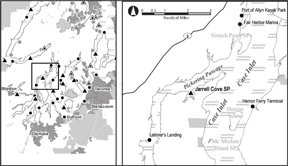
Location: Jarrell Cove State Park is located on the eastern shore of Pickering Passage, 2 miles south of Dougall Point at the northern end of Harstene Island. The site is located above campsite # 21.
Hazards: Mud at low tide
Sites: 1
Water: Spigots located in campground
Sanitation: Restrooms in the center of the park
Overflow: In the rest of campground
Fires: Fire rings available, but not at the water trail site.
Extras: Groceries and supplies available at a marina on the opposite shore
Fees: $12/night for up to 4 in site
Special Considerations: The park provides two kitchen shelters without electricity, plus four sheltered and 10 unsheltered picnic tables. To reserve the kitchen shelters, call 888.CAMPOUT (226.7688).
Natural History: The park is named after Mrs. Philora Jarrel, the first pioneer woman to settle on the island. Jarrell Cove was acquired by the state in four parcels between 1953 and 1969.
Reservations: No
Latitude: 47.284416
Longitude: -122.885233
Additional Resources: Google Maps Page, Guide Book PDF
2 thoughts on “Jarrell Cove State Park”
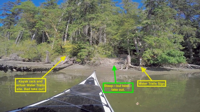
Really rough take out made worse by it’s frequent use by other campers as an unmaintained “beach access” point. Brutal for a solo paddler, and I imagine a couple struggling with a heavy double could easily slip and drop a boat.I talked with ranger about this and he showed some interest in a proposal for rock terrace steps and/or straightening out the angled stairway next to the dock 100 yards away. (These steps were used by some paddlers I saw, but it is one of those very thin stairways with a 45 degree angle in the middle; tough for kayak portaging.)
The Water Trails site itself:
Rack is in good shape.
The tent area is sharp, tent ripping gravel.
I camped instead at the (more expensive but really nice) pay campsite at top of green arrow below. Wonderful sand tent pad and great views. Ranger agreed this pay site is best site in whole campground.
Marina across the little bay has a wonderful kayak takeout at right (N) end of its picnic area. And hey, they have ice cream and beer.
Are the tidal currents strong through Pickering Passage by Jarrell Cove State Park? We read how they can be really strong in Hammersley Inlet. Thanks