 Across the channel from the Swinomish Reservation, this site in Pioneer Park offers a commanding view of La Conner on the Skagit delta. North of the park, nearby downtown La Conner offers eateries, watering holes, local art, and a historical museum. Pioneer Park is between two prime paddling and wildlife destinations: the Padilla Bay National Estuarine Research Reserve to the north and the Skagit Wildlife Area to the south.
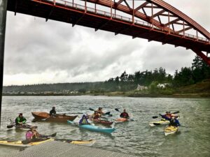
This picture was taken at the boat ramp near our site during on of our “Paddle and Picnics”.
Location: Pioneer Park is at the foot of the orange Rainbow Bridge in La Conner. The CMT site is across the street from the public boat ramp, on a knoll between the parking lot and the bridge.
Hazards: Narrow channels such as the Swinomish often have heavy currents. Also, be aware of frequent small boat traffic.
Sites: One area, space for 3-4 tents
Water: Kitchen area of the pavillion has industrial sinks, faucets, and spigots. Restrooms also have running water.
Sanitation: Well-maintained restrooms with flush toilet and sinks next to pavillion
Overflow: South of CMT site, past pavillion - by permit only, call Town of La Conner 360.466.3901.
Fires: No open fires
Extras: Enjoy hiking trails in Pioneer Park or walk to the quaint town of La Conner for some local flavor.
Fees: $8 donation, pay at boat ramp
Special Considerations: The Swinomish Channel current can be difficult to predict. The actual time of slack water and duration of current flow are dependent on the range between high and low water, and are affected by river runoff. Follow these rules of thumb to help estimate current: - Use Seattle tides and add 30 minutes -Slackwater occurs 2.5 - 4 hours after high or low water at Seattle +30 minutes - Current flows north 2.5 - 4 hours before high water to 2.5 - 4 hours after high water - Current flows south 2.5 - 4 hours after low water
Natural History: The 11-mile-long Swinomish Channel connects Padilla Bay with the Saratoga Passage, providing inland passage for tugs, fishing boats, freighters, and recreational craft. Dredging of the man-made cut was completed in 1937 through what was once called Swinomish Slough, a system of salt marshes, shallow sloughs, and mud flats. La Conner’s working waterfront is the product of a navigable Swinomish Channel.
Max People:
Max Nights: 2
Reservations:
Latitude: 48.3862
Longitude: -122.5014