The 367 miles of the Northwest Discovery Water Trail have many faces. Much of the water trail is on lakes created by four dams on the Lower Snake River and four dams on the Columbia River. The land surrounding these rivers ranges from dry and remote desert country on the eastern portion of the trail to moist forested lands like the Columbia River Gorge on the western trail sections. Although most of the trail route is rural, there are some parts adjacent to larger urban communities. This section will help you become aware of conditions you might encounter when traveling the NWDWT. At a minimum, be aware of the following:
Water Conditions
Water levels on the Columbia vary greatly day to day due to water releases from the upriver dams and seasonal flows. Once source of water flow information is the NOAA River Forecast Center website. From the Bonneville Dam downriver to the Pacific Ocean, the river currents and water levels are also influenced by the tide. The Columbia experiences two high and two low tides in each 24-hour period. It takes about 6 hours for the high tide to reach all the way from the riverís mouth to Bonneville. During this period the tide works against the river current. When the tide changes, it works with the current, speeding the flow downriver. Boaters must be aware of these conditions, especially when mooring or anchoring their vessels. Anchor only off the bow, and use an anchor line 5 to 7 times the depth of the water, equipped with a float.
Finding the Channel
The navigation channel may run to the bank in some sections, while in other areas, the channel is extremely narrow and very near one side of the river or the other. The navigation channels from Lewiston, Idaho at the confluence of the Snake and Clearwater rivers, and on the Columbia river, are marked by aids to navigation as shown on National Oceanographic and Atmospheric Administration (NOAA) navigation charts. Watercraft operators should be familiar with these aids and the navigation rules of the road. To avoid unmarked structures boat operators are advised to stay within the river channel. Small boats should stay as close to the outside edges of the channel as possible, so as not to impede any commercial vessels that can safely navigate only in the channel.
Water Hazards 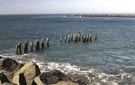
 Rivers are full of floating debris, shallow areas, submerged stumps, logs and rocks. Be on the lookout for obstructions near the shoreline. Remains of old piers and wing dams protrude frequently from the shores of the Columbia. Never approach a wing dam from upriver, the current can pin a vessel against the piles or cause the boat to capsize. During periods of high water, wing dams can be just inches below the surface. Gill nets are also common along certain stretches of the river. The nets are stretched out and suspended from small floats along the top edge of the net. They are difficult to see and can cause significant problems or damage to your boat.